Hurricane Erin: Rapid Intensification & Tech’s Role in Tracking Storms
Hurricane Erin’s Rapid Intensification: A Category 5 Storm
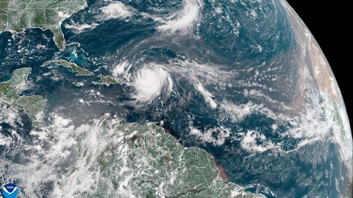
The Atlantic Ocean has been brewing up some weather lately, and Hurricane Erin is the latest storm to grab headlines. What started as a tropical disturbance quickly morphed into a powerful Category 5 hurricane, showcasing a phenomenon known as rapid intensification. This means the storm’s wind speeds increased dramatically in a short period.
According to the National Hurricane Center, Hurricane Erin reached Category 5 status with sustained winds of 160 mph. This rapid strengthening has made it a historic storm, particularly due to its early-season intensification.
Fortunately, early projections suggest that Erin is unlikely to make direct landfall, posing a lower risk of catastrophic damage. The storm is expected to pass north of the Caribbean islands, turn northward before reaching the Bahamas and the Eastern United States, and eventually travel between Atlantic Canada and Bermuda.
The Science Behind Rapid Intensification
What causes a hurricane to rapidly intensify? It’s a complex interplay of factors, including:
- Warm Ocean Waters: Hurricanes draw energy from warm ocean water. The warmer the water, the more fuel the storm has.
- Low Wind Shear: Wind shear, which is the change in wind speed and direction with altitude, can disrupt a hurricane’s structure. Low wind shear allows the storm to organize and strengthen.
- Moist Atmosphere: A moist atmosphere provides the storm with the necessary moisture to fuel its thunderstorms.
When these conditions align, a hurricane can undergo rapid intensification, becoming significantly stronger in a matter of hours.
Technology’s Crucial Role in Hurricane Tracking and Prediction
Modern technology plays a critical role in tracking hurricanes like Erin and predicting their path and intensity. Here are some key technologies:
- Satellites: Satellites provide a bird’s-eye view of the storm, allowing meteorologists to monitor its development and movement. Geostationary Operational Environmental Satellites (GOES) are particularly important.
- Hurricane Hunter Aircraft: These specialized aircraft fly directly into hurricanes to collect data on wind speed, pressure, and temperature. The data is crucial for understanding the storm’s structure and intensity.
- Computer Models: Sophisticated computer models use data from satellites, aircraft, and other sources to predict the future path and intensity of hurricanes. These models are constantly being improved to provide more accurate forecasts.
- Advanced Radar Systems: Doppler radar systems on land and at sea provide real-time information about the storm’s rainfall and wind patterns.
Without these technologies, it would be much more difficult to track hurricanes and warn people in their path.
The Future of Hurricane Prediction: AI and Machine Learning
Artificial intelligence (AI) and machine learning (ML) are increasingly being used to improve hurricane prediction. AI can analyze vast amounts of data from various sources to identify patterns and predict how a hurricane will behave.
For example, AI can be used to:
- Improve the accuracy of computer models: AI can help identify and correct biases in computer models, leading to more accurate forecasts.
- Predict rapid intensification: AI can analyze data to identify the factors that are most likely to lead to rapid intensification, giving forecasters more time to prepare.
- Optimize evacuation plans: AI can be used to simulate different evacuation scenarios and identify the most efficient evacuation routes.
As AI technology continues to develop, it is likely to play an even more important role in hurricane prediction and preparedness.
Actionable Takeaway: Stay Informed and Prepared
The best way to protect yourself from hurricanes is to stay informed and be prepared. Here are some tips:
- Monitor weather forecasts: Pay attention to weather forecasts from reputable sources, such as the National Hurricane Center.
- Develop a hurricane plan: Create a plan that includes evacuation routes, emergency supplies, and communication strategies.
- Know your evacuation zone: Find out if you live in an evacuation zone and know where to go if an evacuation is ordered.
- Secure your property: Take steps to protect your home from wind and water damage, such as boarding up windows and trimming trees.
FAQ About Hurricanes
- What is a hurricane? A hurricane is a tropical cyclone with sustained winds of at least 74 mph.
- How are hurricanes named? Hurricanes are named alphabetically each year, using a list of names that are recycled every six years.
- What is the Saffir-Simpson Hurricane Wind Scale? The Saffir-Simpson Hurricane Wind Scale is a 1-to-5 scale that classifies hurricanes based on their sustained wind speeds.
- What is a storm surge? A storm surge is a rise in sea level caused by a hurricane’s winds pushing water ashore. Storm surge is often the most dangerous aspect of a hurricane.
Key Takeaways
- Hurricane Erin rapidly intensified into a Category 5 storm.
- Technology, including satellites, aircraft, and computer models, plays a crucial role in tracking and predicting hurricanes.
- AI and machine learning are being used to improve hurricane prediction.
- Staying informed and prepared is essential for protecting yourself from hurricanes.
By understanding the science behind hurricanes and utilizing available technology, we can better prepare for and mitigate the impact of these powerful storms.
Source: Ars Technica


